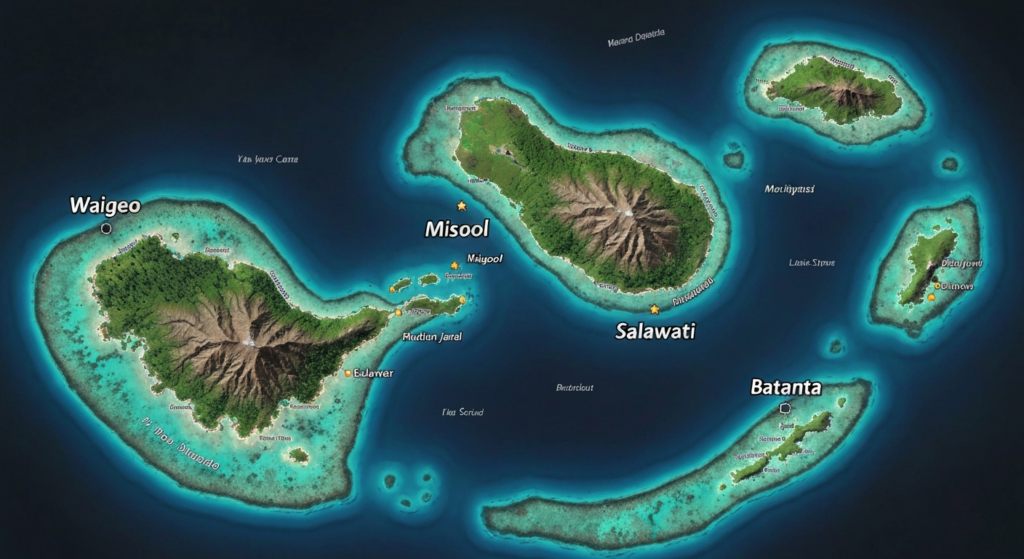
Understanding Raja Ampat’s Geography
Raja Ampat, meaning “Four Kings” in Indonesian, derives its name from the four major islands that anchor this vast archipelago. Situated between 0°-2° South latitude and 129°-132° East longitude, the region occupies a strategic position at the heart of the Coral Triangle—the global epicenter of marine biodiversity. The archipelago stretches across an area larger than Belgium, yet most of its 1,500+ islands remain uninhabited, preserving pristine ecosystems that have evolved over millions of years.
The geography of Raja Ampat is extraordinarily diverse. Towering karst limestone formations rise dramatically from turquoise lagoons, creating the iconic mushroom-shaped islands that define the region’s visual identity. Dense tropical rainforests blanket the larger islands, while mangrove systems fringe protected bays and river mouths. Underwater, the topography is equally spectacular—sheer walls plunge hundreds of meters into abyssal depths, while shallow coral gardens carpet vast reef flats with living color.
Understanding Raja Ampat’s map is essential for planning your visit. The archipelago is divided into distinct zones, each offering unique experiences. The northern sector around Waigeo Island encompasses the famous Wayag lagoon, Kabui Bay passage, and the bird-of-paradise forests of Gam Island. The central zone features the Dampier Strait—one of the world’s most nutrient-rich marine corridors—connecting Waigeo to Batanta and creating powerful currents that attract manta rays, sharks, and enormous schools of fish. The southern region around Misool Island harbors hidden lagoons, ancient rock art sites, and some of the highest coral diversity ever recorded on a single reef.

The Four King Islands
Waigeo Island
The largest island and administrative capital. Home to Waisai town, Wayag iconic viewpoint, Kabui Bay, and the famous Arborek village. Most liveaboard itineraries begin and end here.
Misool Island
The southern jewel featuring hidden lagoons, ancient rock art dating back 5,000 years, and the Misool Marine Reserve—home to the highest coral species count ever recorded on a single reef system.
Salawati & Batanta
Less visited but equally magnificent. Salawati offers pristine mangrove ecosystems and bird-watching. Batanta features waterfalls, endemic species, and untouched reefs along the Dampier Strait.
Key Dive & Snorkel Zones
Raja Ampat’s marine territory is organized into several distinct diving and snorkeling zones, each with unique characteristics shaped by currents, depth profiles, and reef structures. The Dampier Strait between Waigeo and Batanta is the most action-packed zone, where nutrient-rich currents from the Pacific funnel through narrow channels, creating conditions for spectacular manta ray cleaning stations at Manta Sandy and Eagle Rock. Cape Kri, located at the mouth of the strait, holds the world record for the most fish species counted on a single dive—374 species in one 90-minute session.
The Fam Islands cluster northwest of Batanta offers calmer conditions with stunning soft coral gardens draped over underwater ridges. Penemu Island’s hidden lagoon is accessible only through a narrow channel and reveals a secret turquoise paradise surrounded by towering karst cliffs. Wayag, at the northern extreme, presents the archipelago’s most photographed landscape—dozens of mushroom-shaped limestone islands emerging from crystal-clear water, visible from a challenging hilltop viewpoint that rewards climbers with a 360-degree panorama.
The southern Misool sector requires dedicated expedition planning but delivers unparalleled rewards. The No Man’s Land dive site features barrel sponges taller than divers, while Boo Windows presents natural rock arches framing underwater passages filled with soft corals in every imaginable color. The Misool Marine Reserve, established through a landmark partnership between conservation organizations and local communities, has seen fish biomass increase by over 250% since protection began.
Getting Around the Map
Transportation between Raja Ampat’s islands requires careful planning, as distances are significant and weather conditions can change rapidly. From Sorong—the gateway city on mainland Papua—fast ferries depart daily to Waisai on Waigeo Island, covering the 2.5-hour crossing through open sea. From Waisai, speedboat charters connect to homestays, dive resorts, and popular destinations throughout the northern and central zones. Travel to Misool requires either a dedicated liveaboard voyage or a long-range speedboat charter from Sorong, typically taking 4-6 hours depending on sea conditions.
Most visitors explore Raja Ampat aboard liveaboard vessels, which serve as floating hotels navigating between dive sites and island attractions. This approach eliminates the logistical complexity of island-hopping by independent speedboat and ensures access to remote sites that are difficult to reach from land-based accommodations. For those preferring resort-based holidays, strategic positioning at locations like Kri Island, Arborek, or Misool provides excellent access to nearby reefs while maintaining the comfort of permanent structures.
Frequently Asked Questions
How many islands are in Raja Ampat?
Raja Ampat comprises over 1,500 islands, cays, and shoals spread across approximately 40,000 square kilometers of ocean. Only about 35 islands are permanently inhabited, leaving the vast majority in pristine natural condition. The four main islands—Waigeo, Misool, Salawati, and Batanta—account for most of the land area and population.
Where exactly is Raja Ampat located?
Raja Ampat is located off the northwest tip of the Bird’s Head Peninsula in West Papua province, Indonesia. It sits at the convergence of the Pacific and Indian Oceans, positioned between 0°-2° South latitude and 129°-132° East longitude. The nearest major city is Sorong, which serves as the gateway with daily flights from Jakarta, Makassar, and Manado.
Which area of Raja Ampat is best for diving?
The Dampier Strait between Waigeo and Batanta is considered the best overall diving area, featuring world-famous sites like Cape Kri, Manta Sandy, and Blue Magic. However, Misool offers superior soft coral diversity, while the Fam Islands provide excellent macro diving. Your choice depends on marine life preferences and available time.
Can I see the whole of Raja Ampat in one trip?
Covering all of Raja Ampat in a single trip is challenging due to the vast distances involved. A 7-day liveaboard typically covers either the northern zone (Dampier Strait + Wayag) or the southern zone (Misool). A comprehensive 10-14 day expedition can cover both zones. Land-based visitors usually explore one area thoroughly rather than rushing between distant sites.
Plan Your Raja Ampat Expedition
Let our local experts help you navigate Raja Ampat’s islands and create your perfect itinerary.